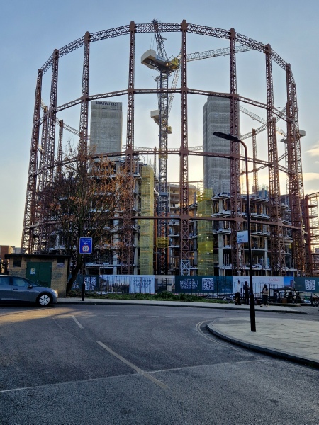
Beyond the Cat and Mutton bridge you will see evidence of the Bethnal Green Gas Works, built by the Imperial Gas Company. Between the Cat and Mutton bridge and the first entrance to Victoria Park, the south bank of the canal lies in Tower Hamlets and the north in Hackney. The main gasometer (1), completed in the 1860s, was, at one time, the biggest in the National Gas grid. Redevelopment of the area means apartment blocks, similar to those at Kings Cross, are being built inside the guides and with a change of use naturally comes a change of name. Although the song ‘Dirty Old Town’ was written about Salford some 70 years ago the references to the gasworks and the old canal and the fact that the first boat to leave City Road basin in 1820 was bound for Lancashire seem to make it apt somehow.
From the bridge you can walk along Andrews Road, which runs by the canal for a couple of hundred yards. You will find steps down to the towpath almost opposite the gasometer and there, as if to emphasise the right of this part of the canal to be regarded as the fountainhead of romance, there was once a marriage proposal (2) now, sadly, sprayed over. I’m not sure if it was the real thing or an innovative piece of canal bank work (by Canal Banksy?) but perhaps, here in Hackney, as in Salford, someone met their love and cultivated their dreams by the gasworks and the old canal. And of course, if the message was genuine, we must wonder if the ‘best damn girl’ accepted.
There is a curious link between Lancashire, canals and marriage proposals. Had the matrimonial plans of the Duke of Bridgewater gone according to plan he would probably never have opened the Canal Age, which eventually led to more than one 'Dirty Old Town'. Now, a quarter of a millennium on, years on, a new song might still have a line about meeting a girl by an old Lancashire canal, but this is more likely to be by the wall of an old kitchen garden rather than that of a gasworks. Click on the button to the left to make sense of this suggestion!
Right opposite Proposal Steps is Containerville, (3) a place where micro-businesses and start ups can find their feet in one of 30 converted shipping containers. It is good to see that entrepreneurship is as alive and kicking as in the Thomas Briggs building and we must hope that the enterprises will flourish, especially as Bethnal Green was always the home of the artisan and the small workshop. Throughout much of the late C19th and C20th furniture production was of prime importance in the borough, but the clothing industry was well established too. According to the council guide for 1958 those for whom ‘price is no object’ would look to items produced by Bethnal Green women - as the skill and finish of their needlework surpassed all others. Caps and headgear were a particular speciality too. The same guide reported that the idea of using white plastic instead of white duck in sailors’ and Royal Marine caps emanated from the borough and one had recently been sent to the United States so it could be copied by the U.S. Marines.
A little beyond Containerville are a couple of houses (4) which, I would guess, are the oldest on the banks below City Road basin. A few hundred yards from the canal, on Hackney Road, there are several fine residences, one of which has a plaque indicating it was constructed in 1820, the year in which the canal was opened. Perhaps they were built with one of the first consignments of bricks delivered along the new transport route. The canal-side houses have recently been completely renovated (5). I am glad they were not demolished as, oddly, some properties in the East End seem to lay derelict for decades.
When the canal was originally mooted it was intended it would swing south towards the actual green of Bethnal Green from here, but changes took it on a more easterly route, which must account for the kink in the line. Once under Mare Street we will enter the environs of Victoria Park, to which there is an entrance after a few hundred yards, but keep a look out to the right and you may see the intriguing portraits (6) taken by a locally based photographer. The photographs are all of residents of the area and published in the book ‘One Hundred Years: Portraits of a community aged 0 -100’.
After passing over two unofficial, fading ‘keep two meters apart’ signs (7) (and, sandwiched between, a representation of the virus which the whole world came to dread) you will see the ornate Bonner bridge in the distance (8). The bridge carries a road known as the Nightwalk where the Victoria Park market, at which all kinds of organic produce and a selection of international cooked food may be bought, is held every Sunday.
Victoria Park dates from the 1840s and was established as an open space for the growing population of the East End. It was laid out by James Pennethorne. Pennethorne was the adopted son of John Nash (he was possibly the biological son of the Prince Regent) who trained as an architect and took over Nash's business after his death. A map in the National Archives shows that very few changes have been made to the boundaries of the park since 1844, although the original five foot six inch high oak boundary fence has long gone.
Before the 2012 Olympics Victoria Park underwent a facelift and some of the old features were restored, one of which was a C19th pagoda (9), badly damaged in the Second World War. The pagoda was bought from a Chinese exhibition in Hyde Park in the 1850s and George Lansbury, a politician who did much to improve social conditions in the East End, said that, as a boy, he thought Chinese people actually lived there and came out at night to take care of the swans, ducks and other wildfowl. Two bridges have also been built to the 'pagoda island' one of which is named after James Pennethorne. Rowing boats, pedillos and even artwork can now be seen on the water. Once in the park it is pleasant to walk around the lake and you will find a refreshment pavilion on the far side (10).
If you want to end the walk at this point then the best thing to do is to go back to the Nightwalk and cross over the canal. If you continue straight ahead Approach Road will take you to Old Ford Road where you should turn right. Walk along to the junction with Cambridge Heath Road and turn left. Bethnal Green Underground station (Central Line) is a couple of hundred yards ahead. You might like to pop into the Bethnal Green Museum of Childhood before you travel on, which is right on the corner of Old Ford Road and Cambridge Heath Road. If you just want to continue along the canal click the button below to go to the Bethnal Green to Limehouse section.
Kings Cross to Bethnal Green
1
2
3
4
5
7
8
This page 5 of 5


9

10


6
When London Became An Island